Sunday, January 10, 2016

Happy 2016

I've been busy so this post was belated. My apologies if the language seems a little out of date. 

I celebrated the arrival of this year with 25 minutes of dreadful isolation on the roof of my apartment. 

Cascades of fireworks dazzled on the horizon, but none of my neighbors joined me on the rooftop to watch.

On the streets below, furthermore, one could hear the faintest echo (punctuated only on occasion by a rare ecstatic shout). 

Unlike on most nights at this time, barely one or two cars whizzed by on the street (during my duration on the roof).

And yet, an absence of cars did not entail the crowding of sidewalks, even on a night when everyone is relaxing or celebrating the arrival of the New Year.

Moments like these convey most directly the confinement of Los Angeles' population to cars. Two observations come to mind.

1. The block I live on is medium density, a mix of midrise (10-story) and lowrise apartment buildings and duplexes/triplexes. However, scanning (from my rooftop view) due north, a pitch black (mile long) expanse of spacious single-family housing separated my nook from the retail and entertainment district along Sunset Blvd. Looking to the west, a couple more blocks of apartments gave way to yet a vaster expanse of blackness (single-family homes), stretching to the faint lights of Westwood. Finally, to the east, I caught another block of apartments, the corner Ralphs, and then the design and office buildings along Robertson, a short distance away. Interspersed with all this dense development, I caught glimpses of still more patches of single-family homes! A thicker line separated my block from the towers in Wilshire. The problem with walking in Los Angeles is that despite the proliferation of density at a regional level (particularly in the central basin area), much of that density occurs in a patchwork matter, intermittant and dispersed across a wide area (and variety of uses). A person still needs a personal vehicle to access the full spectrum of places he or she needs to go.

2. Our city (and region) incentivizes driving even for short trips where walking and biking could do the job. From free parking, to wide roads (and crappy sidewalks) driving has become so convenient that we (think we) "can't" get around without our cars.

Just my observations. Nothing scientific today.

Have a good year!

Sunday, December 20, 2015

On the Mobility Plan and Rush hour Bus Bunching: Equity for Bus Riders?

I was waiting for the Santa Monica Bus at rush hour last week and was struck by the magnitude of delays caused by congestion.

The buses were backed up not for 10 or even 15 minutes but half an hour or more in the eastbound direction. The bus scheduled for a certain time (say 4:45) would show up later than the scheduled arrival of the following bus (say the 5:00 bus) or of the bus after the (scheduled) following bus.

Furthermore, such onerous delays strike at the busiest point of the day for bus ridership. Not a few but a dozen individuals milled the bus stop (in a part of West Hollywood where few locals likely ride). The bus arrives packed to the brim.

Indeed, (perhaps not so) ironically, the greater number of passengers were headed in the direction with more traffic. A stream of workers and housekeepers pile on the buses for East Hollywood at the same time as the motorist bourgeois head towards the 101 for the suburbs.

The biggest problem with rush hour-induced bus delays, such as that I experienced, is that they result in a woefully reduced supply at the height of the day's demand.

Worse yet, the reduced supply is not a result of the bus company providing either an insufficient number of vehicles (this is the time when the most buses are scheduled) or inadequate seating on each bus but the result of thousands of private drivers, over whom a transit agency like Metro has no control, taking over the right-of-way.

To illustrate with an analogy, its as if a clothing store had the least inventory available on Black Friday, because it was forced to give away its wares to other stores (for them to sell at their Black Friday sales) on that day. To make things more accurate, let's pretend this clothing store is Ross (i.e. catering to a lower-income clientele) and the rapacious thieves are Banana Republic and Bloomingdale's.

As with the clothing store's clients, the customers for Metro's bus services suffer competition over limited inventory (known as "cramming") and long waits for restocking of supplies when getting home from work or school.

The immense delays bus passengers must endure at a time of day when they are most in a hurry, not surprisingly turn many away once they can afford the more convenient mode of travel (sadly, in most cases, the private automobile).

This brings me back to the LA's new Mobility Plan.

Much brouhaha has been made about all the automobile lanes that will be lost to bicyclists, who supposedly comprise only 1% of the city's commuters (and who are also hipster elitists, at that).

However, what detractors conveniently ignore is the plan's sweeping Transit Enhanced Network, which will create all-day bus lanes (the ""comprehensive streets") along 13 of the city's most highly-traveled corridors (compare the Transit Enhanced Network map with this list by LetsgoLA) and peak-hour bus lanes on many more (the "moderate plus streets", including my favorite, Beverly Blvd.!).

By allowing for a faster frequency of bus arrivals (assuming that cars respect the bus lanes!) at a time when demand is highest (and speed most desired), Metro and other bus agencies operating in the city can more adequately serve the needs of their clientele.

That's not called elitism but equity.

On a side note:  To those who cry that drivers will suffer an even more severe loss of productive time if a lane is taken out for buses, I say:

 (1) Congestion is already bad enough as it is at rush hour on streets like Santa Monica. How much  worse can it get?

(2)  Cars don't have to pull over and wait for passengers to board every few blocks the way buses do, giving them a natural advantage under the same traffic conditions.

And (3) Cars can always use Waze to meander through side streets when traffic gets bad on arterials. Buses have to stick tho their arterial routes through thick and thin (at least until that far-off point in the future when large agencies like Metro acquire and implement the technology for on-demand scheduling).

Friday, December 11, 2015

Tram-trains for Los Angeles??

As many of you know, I have long been frustrated with the way in which Los Angeles County Metro handles transit expansion.

Its not just that the agency keeps determining construction based on political expediency (rather than ridership levels or trip reduction) but that the light-rail technologies it favors are wholly out-of-sync with Los Angeles' gargantuan urban form.

For instance, the trains on the Gold Line, which will soon offer service to Azusa through the Foothill Extension, currently have an average speed of only 21 miles per hour on its course from East Los Angeles to Pasadena. The entire journey takes about 54 minutes to complete (I frequently completed this route, back when I worked as I delivery driver, in as little than 25 minutes).

Part of the slowdown has to do with the numerous grade-level crossings the line must traverse. (something I could save a rant for at another time) But another is speed. The Ansaldobreda P2550 trains the agency uses have a top operating speed of 65 miles per hour, an upper speed limit typical for light rail (http://www.rtd-fastracks.com/main_398).

Although this may seem high, one has to remember that this is the maximum speed! On a free-flowing freeway, by contrast, cars routinely average 70 miles per hour (even when the posted speeds say 65 miles per hour) or higher.

Light-rail makes a lot of sense on short to medium-length routes through dense inner-city neighborhoods (e.g. Downtown or Boyle Heights) where it complements urban form and allows for frequent stops. And yet, on long routes to more outlying neighborhoods, distances which drivers would travel by freeway, a grade-separated technology that travels at faster speeds is needed.

What I'm thinking of, on routes such as the Gold Line Extension and the Sepulveda Pass line is a high-frequency form of commuter rail.


Commuter rail generally has a higher speed limit than light rail (ranging between 83 miles per hour and 125 miles per hour on the EMD F59PH locomotives that predominate on the Metrolink system). Almost all of the railway right-of-ways that are slated for light rail lines have operated as conventional railroad lines so conversion to commuter rail would be cheaper than light rail.

In addition to the construction of new commuter rail lines, the solution will require increasing the pitifully low frequencies on the extant Metrolink system (which currently only serves peripheral suburbs outside Los Angeles County)  as well as adding both infill stations and outbound "reverse commute trains" (on the Orange County and Ventura County Lines).

In regards to commuter rail's interface with the light rail system, two options would be available.

One possible solution is to have light rail (and subway lines) serve the denser inner districts of Los Angeles County line (for instance, along the Wilshire Corridor and Gold Line to Pasadena) while having commuter rail take over for the outlying districts. For instance, one could ride the Gold Line  up to the Lake Station in Pasadena but then connect to a commuter rail line (running from Burbank to San Bernadino) for the journey to Monrovia.  In this sense, the transit system would mirror the historic division between the "Red Cars" and the "Yellow Cars" in Los Angeles' streetcar era.

A more exciting possibility would be the type of system found in the German city of Karlsruhe. The city's "Stadtbahn" seamlessly integrates tram lines in the city center with commuter lines to the suburbs, System cars are developed for compatibility with both tram and train tracks and electrification requiring only a quick change of wiring to transition between the two. It would be the equivalent (should an analagous "subway-train" vehicle be devised) of combining the purple line to Westwood with the Metrolink San Bernadino Line, so as to allow for a single journey from Miracle Mile to West Covina.

Is it a train? Is it a tram? No, its a tram-train!!

Given that such infrastructure would utilize existing infrastructure (both light rail or subway and rail), only minor improvements to bridge the gaps between the light-rail/subway and train tracks, besides the production of the vehicles themselves.

I don't know if a subway-rail interface is possible but the light rail-rail interface should be (given light-rail's similarity to a tramway).

Have the folks at Metro ever explored this possibility? Do they even know about Karlsruhe?

Sunday, November 22, 2015

Thoughts on Paris and Brussels

The attacks in Paris the week before last, came as a tremendous shock to me, as I am sure they did to many others.

What brought the barbarism especially close to home for me was the fact that my sister was visiting Paris earlier that week. She left on the night of the 11th.

Had she stayed only 48 hours longer, she could have been out on the Place du Republique or Place de la Nation and been killed or injured. 

It is difficult to understand and impossible to condone the impulses that lead people to pursue such horrific slaughter.

And yet, going out on the offensive against Islamic State, as France seems to have chosen, may only accentuate the violence in the warlands of the Levant. while drawing thousands more testosterone-fueled 20-something's from Europe's marginalized muslim communities into the war against the west. 

What is needed is not conflict but containment, as Barry Posen of the Atlantic explains best (see link).

Friday, November 13, 2015

Reflections on yesterday evening's Transit Coalition event: a wake-up call for better governance?

Yesterday evening I attended a dinner talk, hosted by the Transit Coalition, with Metro's Chief Planning Officer, Martha Wellborne .

The food was ample and the attendees were cordial. And yet, I couldn't help but leave disappointed by the limited vision Welborne conveyed for Metro's Measure R transit projects.

I was already painfully aware that the Metro Crenshaw line will be truncated at the Expo Line, a good distance from Hollywood or the Wilshire Corridor (or anything except Leimert Park, really).

I had forgotten, however, that Metro not only had put the Sepulveda Pass rail project on a back-burner but that it was evaluating an "East San Fernando Valley Corridor," following the Sepulveda Pass rail project's logical extension into the valley (up Van Nuys Bulwevard), as an entirely separate project, that was taking priority over the Sepulveda Pass rail link...

Welborne acknowledged that she would "hope" to see the Van Nuys project integrated with the Sepulveda Pass project, indicating that the most viable and fruitful outcome was only aspirational, since one link would be evaluated separately and on a more advanced timetable than the other.

When I asked Welborne, why these projects, and similar sets of projects (e.g. Crenshaw Line and extension, Purple Line into the future) could not be integrated-even at the cost of delaying them further into the future, Welborne brought up the large price tag but added in, even more tellingly, the phrase "politics." People in other regions, she said, might not like billions of dollars pouring into a project on the Westside or Central La.

As she hinted, the Metro agency is responsible to the entire county of Los Angeles, not just its most densely populated areas. Its board, comprised of the five county supervisors and the mayors of Los Angeles and four other cities from different sections of the region, cannot help escape getting caught up in factional politics.

Conflict between the city of Los Angeles and outlying regions of the county requires that projects constructed in Los Angeles' denser, more congested urban corridors (like the Expo Line Phase 2 and Purple Line Extension) be "balanced" with projects in outlying peripheral suburbs (like the Gold Line Foothill extension).

The result is that Metro tends to avoid big price-tag projects (like the Sepulveda Pass Line)-even where benefits far exceed costs. At the same time, money flows towards many half-hearted measures (like the truncated Crenshaw Line, the East Valley Corridor and-in some previously discussed aspects-the Expo Line) as well as lines in areas that lack the housing or jobs density to support transit use. (not all, but much of the foothill extension).

Of course, this means of expansion is by no means sustainable. In order for Metro to adequately serve the LA area's public transit needs, it will need to dissolve or undergo a radical change of structure.

A particularly promising option, better tailored to Los Angeles County's vast (urban) geographies of scale would involve devolving certain transit operations (or construction) to either more localized transit operators. The former could be existing municipal operators, like Big Blue Bus, although I feel (given the sheer number of sizable municipalities in LA County) that geographically-rooted entities, like Foothill Transit (think "Valley transit" or "Westside Transit") would be better equipped for the task.

Metro might "offsource" operations on a geographic basis, giving up operations in areas like the San Gabriel Valley and South Bay and focusing on the denser "Central" area of the LA Basin (i.e. Central and South LA and the Westside).

Alternatively, Metro might choose to devolve a specific type of operation on a countywide level (either to local operators or private-sector contractors), say buses, while maintaining its subway and light rail network, much the way BART operates in the Bay Area. Like BART, Metro could even come to operate a "core" regional rail and bus rapid transit system (of priority routes), while allowing local operators to construct rapid transit projects that serve a more local clientele (the "Munis" of Greater LA).

In order for such a system to thrive, Metro and the local operators would have to agree on an integrated fare system and a certain level of service coordination. The Bay Area, unfortunately, does not offer a good example. Looking abroad however, Seoul, where two private and two public operators divide up the city's massive subway system while conforming to a single fare structure, offers a great example.

Unfortunately, getting two agencies in LA County to agree on anything can be difficult enough.

Maybe my proposed solution is a bit naive. And maybe I am being a bit too hard on Metro (which, as Welborne noted, already has the third highest ridership of any transit agency in the country).

And yet, as Metro prepares to request another half-cent sales tax increase, the eyes of LA (and the country) are on it to see if it can get serious about addressing LA's mobility challenges. And that will require more than a hodge-podge of compromises and stopgaps.

Friday, November 6, 2015

Six Rail and Bus Rapid Transit Lines that Metro should add to its List of Long-term Projects

This year Los Angeles County Metro Rail celebrated its 25th anniversary. Despite having constructed six rail lines and two bus rapid transit lines during this quarter century, public transit retains a mode share of just 10.8 percent of the city of Los Angeles’ commuting population (as of 2013) and traffic gridlock is a constant feature roadways throughout the region. Understandably, transit ridership follows no simple formula. The degree of patronage of a particular transit line depends on a host of environmental factors including surrounding residential and job density1, the level of roadway congestion and parking availability2. Operational aspects such as line frequency and upkeep of vehicles and waiting areas3 also influence line ridership, although these factors depend more on system management rather than the qualities of a particular line. Even strong patronage of a transit line, may not necessarily draw cars off the road, if more take their place. Nevertheless, of all the hypothetical rail and bus rapid transit routes (or line extensions) that Metro has not yet greenlighted (at least in the short term), the following offer the greatest potential in terms of ridership and environmental impact. Metro should, accordingly, incorporate these routes into its expansion efforts in the years to come.


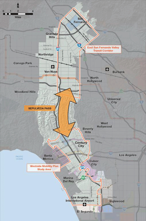
sepulveda_pass_project_map.gif
An Integrated Sepulveda Pass rail project could ease traffic and improve mobility on one of the nation’s most congested corridors.
Sepulveda Pass or Westwood-Van Nuys Light Rail/Heavy Rail
The stretch of the 405 between Westwood and Sherman Oaks is one of the most congested freeway corridors in the country and for a good reason. To the west of the freeway, the rugged terrain of the Santa Monica Mountains National Recreational Area impedes roadway development, resulting in no transmontane thoroughfare for over six miles (see measurement). To the east, narrow canyons provide for several roadways of limited width and capacity up until the Cahuenga Pass, eight miles distant. As such, the Sepulveda Pass freeway serves as a chokepoint, funneling almost all traffic between the coastal regions of the Los Angeles basin (containing significant job and entertainment clusters, as well as the airport)  and the entire San Fernando Valley (with a residential population of almost two million people and major employment centers in Warner Center, the Sherman Oaks-Encino area and along the old Southern Pacific Railroad line in Van Nuys), as well as regions further north and east (like the Antelope Valley and Pasadena). By forcing single-occupant vehicles into situations of congestion, chokepoints provide one of the best advantages over the automobile for grade separated mass transit vehicles3. Extending to LAX in the South and the Sylmar Metrolink (and future High Speed Rail station) station in the north (see metro’s map),  it is easy to see a transit line that passes through or tunnels near the Sepulveda Pass, becoming one of the most profitable in the system. Such a line can either take the form of heavy rail or light-rail, possibly combined with bus rapid transit (or in my preference, commuter rail).


“Pink” Line/Crenshaw Line Extension
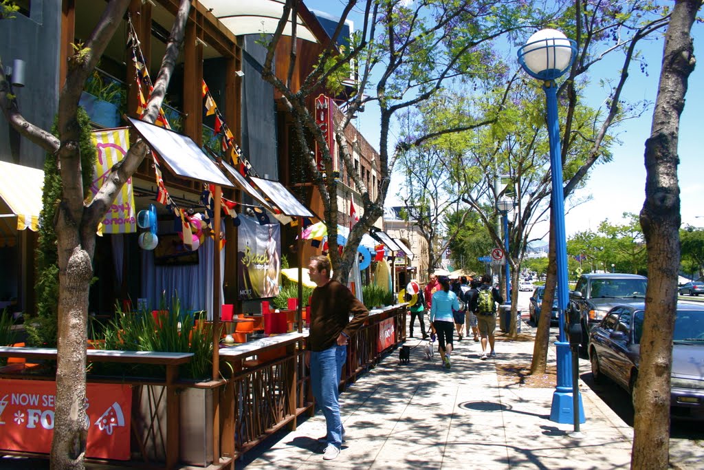
walkablewesthollywood.jpg
A new urbanist’s paradise, dense, walkable West Hollywood would get light-rail connections to the airport, Wilshire Corridor and Hollywood with a Crenshaw Line Extension.
Hollywood is in many ways the epitome of Los Angeles, and for good reason. It is not only the place where the tourists flock to photograph “stars” (or crazy street musicians), but serves as the region’s high-energy nightlife hub.  As such, Hollywood deserves a link to LAX. Extending the Crenshaw Line (currently under construction) from its designated terminus at the Expo/Crenshaw station up to the Red Line would not only accomplish this but integrate West Hollywood (’s) main artery along Santa Monica Blvd., which boasts California’s most walkable commercial district and the LA area’s most prominent LGBT nightlife area, into the Metro rail network. By connecting with the extended Purple Line at either La Brea, Fairfax, or San Vicente (see the map on page 2-5 of this 2009 report), moreover, the northward extension would also feed off airport-bound (or night-life bound) travelers from a wide stretch of the central Wilshire corridor. Unfortunately, this project is not even listed in Metro’s Long-range Transportation Plan (see pg. 21 of the plan), so supporters of this project will need to up their lobby game.  


Beverly Bus Rapid Transit Line (see map):
According to renowned transit consultant, Jarrett Walker, the best-performing transit lines tend to service linear corridors, where activity and employment hubs are distributed evenly along an arterial4. The roughly 2-mile stretch of Beverly Boulevard from Robertson to La Brea fits this concept, as the street weaves together The Grove/Farmers Market shopping complex, CBS studios, the Fairfax retail district, the Beverly Center Mall, Cedars-Sinai Hospital and West Hollywood Design district (the West Third Restaurant District and the famed Melrose Avenue retail corridor lie within a half-mile of the street).  To the east, Beverly offers connections to Koreatown, Downtown and Union Station and to the west, to Beverly Hills and Westwood (should the Rapid Line turn down Santa Monica and Beverly Drive, like the current 14 bus, so that it intersects with the Wilshire Rapid and subway). To the north and south, moreover, the nearest rapid bus lines (the Santa Monica and Wilshire rapids, respectively), are a good mile away, about twice the maximum distance the average person will walk to a frequent bus line. Best of all, no freeway even comes close to this stretch of Beverly (thanks to 1960s-era freeway revolts, there are none within roughly 2.5 miles), while neither Beverly nor its parallel arterial streets (Melrose and Third) are particularly wide. Not surprisingly, Beverly, along with its parallel arterials and side streets, fills up with traffic on both weekdays and weekends. Reserving the outermost lane of Beverly Boulevard for bus travel (with restored Rapid Service), rather than parking would disincentivize further growth in traffic volume while offering an alternative to persisting congestion. Despite current lackluster bus ridership levels along Beverly’s western stretch, the pedestrian-friendly design of many of the storefronts in this area, which front the sidewalk directly, gives a bus rapid transit system with dedicated lanes and well-kept waiting areas all the more potential to mitigate traffic.    


Green Line Extension to Norwalk
One of the most frustrating defects in the current Metro Rail system is the 2.5 mile gap between the eastern terminus of the Green Line and the Orange County Line Metrolink station. This small gap stunts an important connectivity between Orange County’s tourist and commercial destinations and LAX (thereby helping create nasty traffic jams along the stretch of I-605 between I-105 and I-5) and also puts Norwalk’s significant complex of government offices (including the Los Angeles County Clerk’s Office) just beyond the light rail’s reach. Should the Sepulveda Pass project to LAX be completed, an extended Green Line would also offer one stop access-via a transfer at the 96th street station-from Orange and Riverside Counties to the entire Westside. As some point out, the Orange County Line’s current low frequencies (a product of heavy freight use on the tracks) threaten the viability of connection to an all-day light rail service: However, Metrolink can potentially relieve this problem through adding more tracks on the line (as has indeed been proposed by the LOSSAN rail authority, see pg. 34) and should (given the heavy two-way commute volumes). Though it might require tunneling, completing this project, if done right, could significantly boost the Green Line’s long-struggling ridership levels (which are less than that of the phase 1 segment of the Expo Line) and might shift some traffic off the neighboring freeways: a win in the long-term for both Metro and the environment.


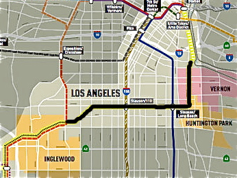
Harborsubdivisiondowntownairport.jpg
The Harbor Subdivision rail corridor runs from Union Station to Inglewood. The black shading indicates the route of metro’s planned Active Transportation Corridor parallel to the tracks.
Harbor Subdivision
Running from Downtown Los Angeles to El Segundo along Slauson Avenue, the Atchison, Topeka and Santa Fe’s abandoned Harbor Subdivision offers a prime route for heavy or light rail (especially with the construction of an adjacent active transportation corridor). A transit line along this abandoned railway would provide a one-seat ride from LAX to Downtown Los Angeles’ Union Station transit hub while creating a east-west transit artery through the heart of South Los Angeles, which has among the largest concentrations of transit-dependent and carless residents in Los Angeles County (but is only served by rail transit on the fringes). This line would not only connect South Los Angeles’ residents to three of Los Angeles’ largest jobs centers (the white collar-cores in Downtown LA and El Segundo and the blue collar, industrial core along the LA river in Vernon) but offer one-stop access to regional destinations through Union Station. A highly feasible (based on the track alignments near Slauson station) eastward branch off to Huntington Park, Maywood and Bell would bring one of LA County’s busiest shopping districts and most densely-populated residential areas within reach of both the airport and Westside. Metro has seriously explored this line in the past but has put it on the backburner since approving the Crenshaw Line. With Los Angeles Mayor Eric Garcetti seeking to host thousands of Olympic athletes along the LA River in 2024, this line may get the opportunity for promotion.


Ventura Boulevard Bus Rapid Transit
The lower San Fernando Valley’s primary commercial artery, Ventura Blvd boasts a long stretch of medium-scale dining and retail business, punctuated by several clusters of large-scale office buildings (for instance, near the junctions with Laurel Canyon Blvd in Studio City or Sepulveda Boulevard in Sherman Oaks). Although the hillside neighborhoods to the south are characterized by sprawling McMansions, the north side of the arterial is flanked by medium-density neighborhoods comprised of duplexes and small apartment buildings at least as far as the 405. As the Valley’s southernmost east-west arterial, moreover, Ventura Blvd currently “funnels” bus routes that come down north-south arterials like Reseda, Van Nuys and Woodman, carrying these to transfer points (see map) for overhill travel. Should the Sepulveda Pass Line become reality, this “funnel” function will acquire increased importance as a means of dispersing passengers from the Sepulveda Pass Line across the valley (see Letsgola's map for an example of how this might work). Due to the need to operate multiple routes along this arterial, a bus rapid transit lane from Universal City City Station to Woodland Hills makes the most sense here. Because Ventura Blvd has so many damn automobile lanes already, a dedicated bus lane here will, hopefully, avoid the wrath aroused by the Wilshire Bus Lane. (hopefully…)


  1. Jarret Walker’s Human Transit provides a good, simple explanation for the layman of why (built) density matters for transit.
2. See Chatman, 2008, who suggests that “Network Load Density”, i.e. the number of roadway users per unit of roadway capacity, has a negetive effect on automobile use and a positive impact on alternative forms of travel like transit. http://ced.berkeley.edu/downloads/pubs/faculty/chatman_2008_deconstructing-development-density.pdf


3. Walker. Human Transit. Page 51.
4. Walker. Human Transit. Page 205.

5. Walker. Human Transit. Page 169.

Friday, October 30, 2015

Should we build transit oriented development near transit or construct transit near (transit-friendly) development??

Los Angeles (like other cities around the world) has undertaken several initiatives in recent years to encourage denser commercial and mixed-use development around transit stations.

Such development is necessitated in part because of the dominance of auto-centric (low rise, strip mall style) commercial development near rail lines (for instance by the Vermont/Santa Monica Red Line Station), but even more so by the complete absence of commercial or even residential developments along rail lines (as is the case along much of the Blue and Gold Lines and most of the Orange and Green lines). 

About half of Metro's current rail and bus transit lines, and many of the transit agency's future expansion projects (the Gold Line Extension and West Santa Ana Branch, for instance), follow the old streetcar right-of-ways for some length. (compare the old Pacific Electric Map with the map of Metro's Short-Range Transportation Plan-with both planned and future lines (http://media.metro.net/projects_studies/srtp/report_srtp_2014.pdf, pg. 11 and http://media.metro.net/projects_studies/images/final-2009-LRTP.pdf pg. 39)). .

Concentration of rail mass transit along streetcar right-of-ways makes sense from a cost perspective because the agency can forego the costs of either acquiring (and demolishing) property or tunneling. to build the line. In addition,  a transit line can often utilize the pre-existing rail infrastructure.

However, in the 50 plus years since the death of the Los Angeles Streetcar system, the dense commercial and multi-family residential development that best sustains rail use has frequently migrated away from the old street car corridors or reoriented itself in a more car-friendly fashion.

At the same time, the broad amount of right-of-way space that the old streetcar infrastructure occupied (along with the "divided" street layout that it engendered=e.g. Venice or San Vicente) has frequently transformed successor auto thoroughfares into intimidating highways, where one way through and turn lanes shepherd traffic along as quickly as possible to the detriment of pedestrians (try crossing Burton Way in one sitting). It should be added that those transit corridors which do not parallel railway right-of-ways generally follow broad arterials (such as the Crenshaw line and East San Fernando Valley Corridor) or freeways (the Green Line) that were similarly built out for maximum auto capacity in the postwar era.

Conversely (and indeed, surprisingly), much of LA's densest and most pedestrian-friendly commercial and retail development has arisen along corridor's without any rail history.

For a good hypothetical example, compare Beverly Bouelvard, in the Fairfax and Beverly Grove Districts, with Venice Boulevard on the Westside.


Westbound lanes of Venice Blvd, just west of Overland. Vast, low-density and hostile to pedestrians.


Beverly Boulevard at Vista Street. Clustered, medium-density development on a rather narrow arterial street. 


The former street, which never had any streetcar or rail line, is an arterial of modest width. (two lanes per direction and 70 feet wide) It is relatively easy to walk across (and has wide sidewalks) and runs through areas with a significant amount of multi-family housing. Even more importantly, the stretch from La Brea west to La Cienaga teems with small businesses and office spaces (in addition to larger spaces like the Grove and CBS Studios) that front the street directly rather than hide behind parking lots in a matter akin to so-called "transit-oriented development."  Not surprisingly, this area boasts a high density of jobs, according to the latest census.

Venice, on the other hand, once hosted a branch of the Pacific Electric Railway, whose streetcars ran through the median from Hill Street all the way to the ocean (see page).

Though serving a dense population immediately west of downtown (probably up until Western), the streetcar line's westward stretch served mainly as a commuter line, passing through expanses of low-density suburb and even farmland (see this old photo) en route to the independent city of Venice.

After the streetcar tracks were taken out in 1950, not only was the median paved over but the street widened to create a six-lane auto highway. Even as residential development in surrounding neighborhoods like Palms and Mid-City exploded in the ensuing decades, the new businesses that arose on Venice to serve the new residents' needs tended to be strip malls with generous parking lots.

Given both the street's more congested nature and pedestrian-friendly infrastructure, a transit line along Beverly would better conform to the built environment than one along Venice (there are other reasons to build along Beverly as well that I will discuss in one of my upcoming posts), even though it is the latter that (given its right-of-way) is designated for upgraded Bus Rapid Transit and, possibly a streetcar system (in the long-term), by Los Angeles' Westside Mobility Plan.

Even more glaring, the Expo Line adheres to its railroad right-of-way as it crosses Westwood, passing through a single-family residential area, rather than make a slight northward (underground) detour to service the vibrant commercial district around Westside Pavillion.

The construction costs of deviating from a generous right-of-way may be high in the short-term. But if the development better suits transit, these costs could theoretically be recuperated through higher ridership levels, without the uncertain and often controversial endeavor of constructing dense development in a low density area.

I don't have the intricate knowledge of construction costs necessary to make a definitive policy recommendation for either of the cases I mentioned.

But as Metro still struggles, a quarter century after the opening of its rail system, to attract passengers to lines that do not necessarily get many where they need to go, it might be worth asking whether Metro should look beyond the right-of-way.